Peleliu Island
Peleliu island is located about 23 miles south of Koror island. Peleliu is a reef island and only 5sq miles in size. Population is approximately 700. Palau was a colony of Germany between 1899 and 1914. At the time, Germany developed man industries including phosphate mining and copra harvesting. The Japanese took control in 1915 and continued until 1944. It was during this time that Palauan culture went through its most radical transformation. Japanese expanded the commercial ventures started by the Germans and developed many more.
Peleliu was also the site of one of the bloodiest battles of WW2. In two months of fighting on Peleliu, there were over 20,000 casualities, more than the current-day population of all Palau. During the fighting, Peleliu’s forests were bombed and burned to the ground. Today the island is alive with leafy foliage that have grown up to cover the battle scars.
Historic Peleliu Land Tour.
The island of Peleliu is the site of one of the bloodiest and most prolonged WWII battles in the Pacific. In September 1944, Americans stormed the beach in what was estimated to be a three-day operation as part of General MacArthur's plan to secure Palau and the Philippines. But the battle raged on for three months. Japanese soldiers hid in caves and fought to the bitter end. Many of the caves became sealed graves. It took until March of the following year to secure Peleliu and return it to Palauans, who had fled prior to the invasion.
We will take you on a half day or full day tour of the museum and the actual battle sites. A Japanese command center has been transformed into a unique museum. The building itself is kept in its war damaged state. In it you can see news clippings, war photos, items donated by surviving veterans, old helmets, guns, grenades, bombs and a plethora of other war memorabilia that has been found in Peleliu's jungles and on its beaches.
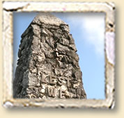
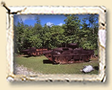
Then we will tour the battle sites, including the old airfield, gun emplacements, American and Japanese tanks, crashed airplane hidden in the jungle, and beach and hilltop memorials. The battle raged from the beaches up into the hills to the top of Bloody Nose Ridge. Now Japanese and U.S. Army memorials stand there.
Peleliu Island MAP
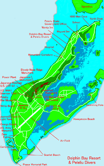
The sites include:
1)Bloody Nose Ridge
---100 steps to the top of the ridge where you have a beautiful view of of Peleliu's jungles and ocean reefs, and the Rock Islands spread out before you.
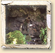
2)U.S. tanker and Japanese cannons in a huge cave.
3)Orange beach & U.S. monument to fallen soldiers.
--- invasion beach by U.S Marines.
4)Zero fighter
--- Japanese airplane crashed in the jungle.
5)Campbeck Dock with rusting landing craft lining its sides
--- built by U.S. for military purposes, now Peleliu south dock.
6)Peace Memorial Park
--- at the southern tip of Peleliu with a beautiful view of the island of Anguar.
7)Air field
--- built and used by the Japanese, it is still used by small airplanes and helicopters today.
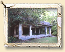
8)Japanese Headquarters building
--- slowly being reclaimed by jungle tree roots and vines, we can still go inside the building, and can see where the bomb landed, the bullet-scarred wall, and the cellars.
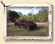
9)Japanese tanker
--- left where it fell.
10)1000 Men Caves
---1000 Men Caves (along the main road to North Dock) to be explored. Some are home to bats and unusual cave spiders; some have a few remaining war artifacts.
11)Honeymoon beach
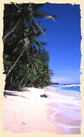
--- beautiful Peleliu east beach, great for beachcombing and picnicing.
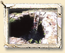
12)Swimming hole
--- a natural hole (with a ladder) where fresh and salt water mixes because it connects underground to the ocean. It's a great place for jumping and cooling down. A favorite playground for local kids.